SARAMA RESOURCES OUTLINES EXTENSIVE GOLD TRENDS AT COSMO GOLD PROJECT
Kilometre-Scale Gold Trends Delineated by Large-Scale Soil Geochemistry Program
Sarama Resources (TSXV:SWA)
PERTH, AUSTRALIA, June 10, 2025 /EINPresswire.com/ -- Highlights
• Extensive gold-in-soil anomalism delineated in recent soil geochemistry program at Cosmo Gold Project
• Program confirms Project is target-rich and hosts multiple significant anomalous gold zones in 8 prospect areas
• Multiple gold trends extend in aggregate for approximately 45km along strike with footprints up to 1.8km in width
• Peak sample value of 94ppb Au returned within a prospective litho-structural setting
• Regional-scale program is the first significant and systematic exploration program conducted at the Project
• Results provide clear focus for future exploration, including infill soil geochemistry and reconnaissance drilling
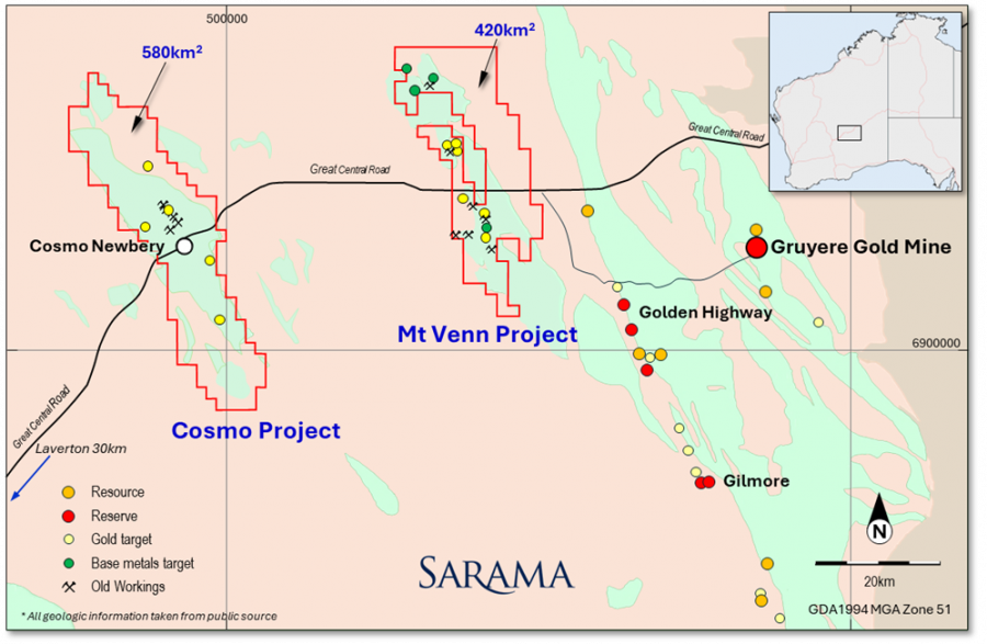
• Project covers 580km² project area and +50km greenstone belt strike length
• Cosmo Project part of Sarama’s 1,000km² exploration position⁽¹˒²˒³⁾ in the prolific Laverton Gold District, close to the producing Gruyere Gold Mine⁽⁴⁾
PERTH, AUSTRALIA / VANCOUVER, CANADA. Sarama Resources Ltd (“Sarama” or the “Company”) (ASX:SRR, TSX-V:SWA) is pleased to announce that several large trends of gold anomalism have been delineated by the recently completed regional soil geochemistry survey at its Cosmo Gold Project (the “Project”)⁽¹˒²⁾ in the Laverton Gold District of Western Australia (refer Figure 1).
The results are the product of the first significant and systematic exploration program conducted on the belt-scale project and the Company is encouraged by the scale of the anomalism and strength of targets delineated. The anomalous trends, which extend in aggregate for approximately 45km and which have individual strike lengths up to approximately 7km, are located in a range of litho-structural settings, illustrating the geological diversity of the Project and its potential to host multiple styles of gold mineralisation.
Sarama’s Executive Chairman, Andrew Dinning commented:
“We are very encouraged by these early results, which represent a strong start to our exploration at the Cosmo Gold Project. The scale and number of gold anomalies highlight the Project’s potential and aligns well with our broader strategy to unlock value across our 1,000km² ⁽¹˒²˒³⁾ landholding in the highly prospective Laverton Gold District. These results help refine our exploration focus and provide a solid foundation for prioritising key targets and planning the next phase of work, including targeted geochemistry and reconnaissance drilling.”
Extensive Gold-in-Soil Anomalism Delineated
The regional soil geochemistry program has successfully delineated numerous zones of extensive gold-in-soil anomalism which will provide an immediate focus for future exploration within the Project’s large 580km² footprint. These gold-in-soil trends are noteworthy given their continuity, coherence and strike extent.
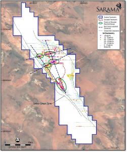
At a high level, several clusters of elevated gold zones can be identified within the global raw assay data (refer Figure 2). These clusters can be interpreted to lie at the intersection of 4 belt-scale lineaments, presumed to be faults or other structural features, generally trending in approximately orthogonal orientations. The north-western trends approximately align with the regionally significant Sefton Shear Zone and in a broad sense, these spatial associations are encouraging and give insight into controls on gold-bearing fluid flow and emplacement throughout the greater Project.
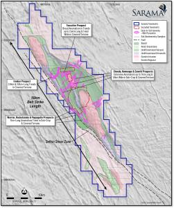
Interpretations of anomalous zones at a prospect level have successfully identified 8 key prospect areas featuring extensive gold-in-soil anomalism which provide an immediate focus for exploration work (refer Figure 3). Delineation of anomalous trends considered the continuity of grouped sample values and interpreted geological, structural and topographical features. The statistical significance of the gold assays in the context of regolith domains was also considered and in general, a 90th percentile gold value threshold was adopted.
Ironbar Prospect
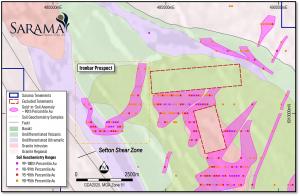
The Ironbar Prospect hosts two trends of kilometre-scale anomalism which intersect in the immediate vicinity of the Sefton Shear Zone (refer Figure 4). These trends are broadly defined by +5ppb Au soil sample values (corresponding to the 90th percentile) and are interpreted to extend for 3.8km and 2.0km strike lengths in orientations of north-north-east (“NNE”) and north-west (“NW”) respectively. The intersection area of the trends contains elevated gold-in-soil values (+10ppb Au) covering a footprint of approximately 600m x 600m with a peak sample value of 20ppb Au.
The high tenor anomalous zone was sampled in sandy cover material and interpretations suggest the intersection of the 2 anomalous trends lies over the contact of an ultramafic unit with a mixed mafic volcanic unit to the east. Airborne magnetic imagery shows a number of subtle magnetic disturbances underlying the Ironbar Prospect, suggestive of NE-trending faults and a small-scale intrusion.
Warrior-Rockatansky-Pappagallo Prospects
The combined Warrior-Rockatansky-Pappagallo Prospects host several NW-trending anomalous zones within a trend strike length of approximately 7km (refer Figure 5). The zones are broadly defined by the 90th percentile gold values within covered and sub-crop domains and are coincident with interpreted mafic and ultramafic volcanic units, which are bounded by a regional granite-gneiss terrane to the west and the late-stage Cosmo Mesogranite unit to the east. Importantly, the NW trend of mineralisation is spatially associated with the belt-scale, NW-trending Sefton Shear Zone.
In the central and southern part of the anomalous trend, several higher tenor zones (+10ppb Au) are present with continuity traced for approximately 4.5km. These potentially reflect bedrock gold mineralisation and Sarama is particularly encouraged by their spatial association with the volcanic/intrusive contact and anomalous magnetic features. Extensive anomalism is also observed in areas overlain by cover, which is significant given the prevalence of sandplain material over the Project. The anomalous trend includes the Project’s peak gold value of 94ppb Au.
Cheedo-Humungus-Zanetti Prospects
The combined Cheedo-Humungus-Zanetti Prospects host extensive gold-in-soil anomalism in cover and sub-crop material along two main trends defined by 90th percentile values (refer Figure 6 at https://saramaresources.com/wp-content/uploads/2025/06/250610-figure-6-cheedo-humungus-zanetti-prospect-scaled.jpg).
A north-east (“NE”) trend extends for approximately 7km and has a footprint up to 1.8km in width with gold values up to 80ppb Au. The broad trend is hosted in a complex regolith setting and some mechanical dispersion of gold from historical small-scale workings has likely occurred in the area and been the subject of shallow (generally <5m) stab holes in rotary-air-blast (“RAB”) drilling. The trend is coincident with disrupted features in magnetic imaging which suggests an association with a structural feature transgressing the volcanic and intrusive units in the immediate area of the anomalism. Ground truthing and further analysis will assist in refining the interpretation and target definition.
A secondary NW-trending anomalous gold zone within the Cheedo Prospect has been interpreted to extend for a strike length of 2.8km in an extensive sandplain area with a peak gold value of 12ppb Au. The anomalous zone is co-incident with the contact of interpreted mafic volcanic and ultramafic rocks in the vicinity of the regionally extensive Sefton Shear Zone. The primary 7km-long NE-trending zone is proximal to this secondary zone and the associated disruptions to magnetic features are also present.
Toecutter Prospect
The Toecutter Prospect hosts two broad anomalous zones extending up to 2.6km in length and 1.4km in width (refer Figure 7 at https://saramaresources.com/wp-content/uploads/2025/06/250610-figure-7-toecutter-prospect-scaled.jpg). The anomalism occurs largely within sandplain material and contains a peak value of 21ppb Au. The anomalism is located on the northern edge of the interpreted Cosmo Mesogranite unit which may play an integral role in the emplacement of gold mineralisation. This broad contact zone of the granitic unit and the adjacent volcanic rocks is considered a prospective area for gold mineralisation and it is encouraging that this type of target has been identified by the recent survey given the regolith setting and complex sampling medium.
Next Steps
Sarama is encouraged with early-stage exploration on the Project to date, particularly with the continuity and extent of the key areas of gold-in-soil anomalism and their general correlation with underlying interpreted geology and structural features.
The soil geochemistry program has highlighted extensive areas of elevated gold-in-soil anomalism that the Company intends to ground truth and plan further infill soil grids around. In addition, planning will commence for reconnaissance drilling in the high-priority areas for which existing soil geochemistry sample density is sufficient for drill targeting.
The recent survey also highlights anomalous zones in unexpected areas that require follow-up including further fieldwork, desktop investigation and potential re-sampling, all of which will be undertaken in parallel with work on the primary targets.
Soil Sample Collection and Analytical Methodology
The majority of the soil geochemistry program was conducted during Q4 2024 - Q1 2025 and was designed to cover broad areas of the 580km² project area as a foundational stage in drill target generation (refer Figure 8 at https://saramaresources.com/wp-content/uploads/2025/06/250610-figure-8-soil-geochemistry-sample-collection.jpg). Grids of 400-800m x 100m oriented east-west were employed for the bulk of the program with sampling of high priority areas conducted on 200m x 100m spacing. In total, samples were taken from approximately 5,000 sites within target areas generated from geophysical surveys and historical ad-hoc exploration works.
Samples were collected at depths of 10-20cm across the Project using a shovel and sieved in the field to produce a minus 0.9mm sub-sample. LabWest’s Ultrafine+ᵀᴹ process was used to further sub-sample this material to produce a final minus 2 micron fraction for multi-element grade determination using aqua regia digest and spectral analysis. For each sample, a total of either 65 or 53 element values were reported, depending on commodities targeted by exploration.
This sample preparation and analytical process was developed and commercialised by CSIRO (the Commonwealth Scientific and Industrial Research Organization) specifically to assist in the exploration of the complex regolith conditions which are prevalent in the Eastern Goldfields of Western Australia. The method targets very fine clay material, which may have been subjected to hydromorphic processes, for analysis with very low detection limits which together can indirectly promote identification of mineralisation anomalism that is heavily masked by cover material or as a result of weathering processes. This is particularly prevalent at the Cosmo Project where large areas are under recent sand cover. The method was not commercially available for the majority of the Project’s exploration history and Sarama is pleased to have been able to leverage this technical advancement in soil geochemistry which has been used by prominent mineral exploration companies.
Analysis of Analytical Results
Regolith, surface geology and topography maps have been developed for the Cosmo Project using remote sensing and airborne geophysical datasets. The resulting interpretations were subsequently ground-truthed at a high level to provide working geological context for exploration targeting and field programs.
Individual samples were assigned a domain coding based on their location within interpreted regolith and rock units of the surface geology and regolith maps. The analytical data for all samples within each domain was then divided into sub-populations by element for statistical analysis. An element correlation matrix was also compiled in order to identify elements that may be commonly associated with gold as the primary target commodity.
Sarama used a range of statistical methods and elemental associations to investigate the raw analytical data and has determined a gold-only values analysis to be most appropriate to identify anomalous zones for further targeting work. Anomalism has been generally defined by 90th percentile gold values within 5 primary regolith/sampling material domains.
This approach provides for the identification of statistically ‘significant’ zones in a particular sampling medium, regardless of the absolute tenor of a specific assay. This is important given many of the areas sampled are under recent cover and gold mineralisation may exhibit a muted analytical response as a consequence. The approach is also useful in identifying continuity of anomalous zones between different sampling mediums which may have significantly different analytical responses in absolute terms (that is, ‘levelling’ or ‘normalising’ the data).
Summary statistics for the program, categorised by regolith/surface geology domains, is included in Appendix B.
About the Cosmo Project
The Cosmo Project is comprised of 7 contiguous exploration tenements covering approximately 580km² in the Eastern Goldfields of Western Australia. It is located approximately 85km north-east of Laverton and 95km west of the world-class Gruyere Gold Mine and is readily accessible via the Great Central Road.
The Project captures one of the most unexplored greenstone belts in Western Australia and with a strike length of +50km, the Cosmo Newbery Belt represents a large and prospective system with gold first being discovered in the area in the 1890’s. Multiple historical gold workings are documented within the Project area and work undertaken to date has identified multiple exploration targets for follow-up.
Despite this significant prospectivity, the Project has seen virtually no modern exploration or drilling of merit due to a lack of land access persisting over a significant period. As a result, the Project has not benefited from the evolution of geochemical and geophysical techniques which now facilitate effective exploration in deeply weathered and complex regolith settings. This is particularly pertinent given approximately 75% of the Project area is under cover.
Following the relatively recent securing of land access, the Project is now available for systematic and modern-day exploration programs to be conducted on a broad scale. Initial soil geochemistry programs conducted by Sarama have outlined extensive gold-in-soil anomalism and future exploration programs, including infill soil geochemistry and reconnaissance drilling, will initially follow-up these promising target areas.
This announcement has been authorised by the Board of Sarama Resources.
Neither TSX Venture Exchange nor its Regulation Services Provider (as that term is defined in policies of the TSX Venture Exchange) accepts responsibility for the adequacy or accuracy of this release.
Other Information
FOOTNOTES, CAUTION REGARDING FORWARD LOOKING INFORMATION,COMPETENT PERSONS’ STATEMENT and QUALIFIED PERSON’S STATEMENT
APPENDICES (Appendix A - D)
Andrew Dinning
Sarama Resources Ltd
+61 8 9363 7600
info@saramaresources.com
Distribution channels: Banking, Finance & Investment Industry, Business & Economy, Companies, Energy Industry, Mining Industry
Legal Disclaimer:
EIN Presswire provides this news content "as is" without warranty of any kind. We do not accept any responsibility or liability for the accuracy, content, images, videos, licenses, completeness, legality, or reliability of the information contained in this article. If you have any complaints or copyright issues related to this article, kindly contact the author above.
Submit your press release


